You Won’t Believe This Secret Terrain Hiding in York
You know what? I stumbled on something wild in York—no, not another cathedral tour. Beneath the cobbled streets and ancient walls lies a hidden world of underground passageways, forgotten valleys, and rivers you didn’t know existed. I never expected such dramatic terrain in a historic city. This is no ordinary walk through time. With every step, the ground shifts, drops, and reveals secrets most tourists completely miss. What appears to be a flat, picturesque English town is in fact a landscape sculpted by water, war, and centuries of human adaptation. The real story of York isn’t just in its museums and monuments—it’s underfoot, in the subtle slopes, dips, and rises that tell a deeper tale of survival, strategy, and nature’s quiet persistence.
The City That Sits on Secrets
York is best known for its towering Minster, its winding medieval streets, and its proud legacy as a Roman and Viking stronghold. But beyond the postcard-perfect facades lies a more complex reality—one shaped not just by history, but by geography. The city’s terrain is far from uniform. Beneath the surface, a network of ancient waterways, buried valleys, and shifting elevations tells a story of natural forces quietly shaping human settlement. While most visitors focus on what rises above ground—the spires, the timber-framed houses, the stone walls—few pause to consider what lies beneath their feet. Yet the land itself has been a silent architect of York’s development.
From its earliest days as the Roman fortress of Eboracum, York’s location was chosen for strategic advantage. Perched at the confluence of the Rivers Ouse and Foss, it offered natural defense and vital transport links. But the land wasn’t just flat ground waiting to be built upon. It was already a mosaic of ridges, wetlands, and shallow valleys. Over centuries, people built over, filled in, and reshaped the landscape, but the original contours never disappeared. They were simply buried, softened, or adapted. Today, those subtle shifts in elevation—some as little as a few feet—still influence drainage patterns, building foundations, and even the way streets meander through the city.
What makes York’s hidden terrain so compelling is how accessible it is, yet how easily overlooked. A slight incline leading down to a narrow alley, a basement level that feels unexpectedly deep, or a patch of damp earth in a courtyard—all can be clues to a much older story. The city didn’t just grow upward; it grew across a living, breathing landscape. By learning to read these signs, travelers gain a richer, more layered understanding of York. It’s not just about seeing the past, but feeling it beneath your shoes, sensing how geography and history are forever intertwined.
Following the Foss: A River That Defines the Lay of the Land
The River Foss may be smaller than the mighty Ouse, but its influence on York’s terrain is profound. Originating from natural springs and fed by underground aquifers, the Foss has quietly shaped the city’s topography for thousands of years. Its winding course created a natural depression—a low-lying corridor that dictated where walls would be built, where roads would avoid, and where floodplains would form. Even today, walking alongside the Foss reveals how the land responds to its presence. The banks rise and fall unexpectedly, with paths dipping into shaded hollows and emerging onto higher ground without warning.
Historically, the Foss served multiple roles: a source of water, a defensive moat, and a natural drainage system. The Vikings and later medieval builders recognized its strategic value, using it to fortify the city’s eastern edge. The river’s path helped define the shape of the old town, creating a natural barrier that complemented the city walls. But more subtly, it carved a valley that persists in the modern landscape. In areas like Foss Islands Road, the road slopes downward as it approaches the river, a reminder that this is a crossing point over a long-standing geological feature. The surrounding streets follow the curve of the land, not just the grid of urban planning.
One of the most telling signs of the Foss’s influence is the way water still gathers in certain areas after heavy rain. Even with modern drainage, some low-lying streets near the river take longer to dry. This isn’t poor engineering—it’s the land remembering its original form. Old maps show marshy areas along the Foss that were gradually filled in during the 18th and 19th centuries, but the memory of those wetlands remains in the soil and slope. Walking this route today, especially in the early morning when mist hovers over the water, one can almost feel the ancient valley breathing beneath the pavement.
Beneath the Bars: The Hidden Dip of the Shambles Area
No visit to York is complete without a stroll down the Shambles, the narrow, crooked street famous for its overhanging timber-framed buildings. But few tourists realize they’re walking through a topographical low point—one that shaped the street’s very existence. The Shambles sits in a natural dip, a minor valley formed by centuries of runoff from the surrounding higher ground. This depression made the area prone to flooding and damp, which is precisely why it was originally used for butchery and meat storage—cool, shaded, and close to water sources.
Look closely, and the clues are everywhere. Many of the buildings along the Shambles have uneven floors, with steps rising or descending between rooms. Some shops have basement entrances that open directly onto the street at a lower level, a sign that the ground has settled or been built up over time. The street itself slopes gently, following the natural fall of the land toward the Foss. Even the famous overhangs—where upper floors nearly touch across the street—may have been partly influenced by the need to stabilize structures on uneven ground.
This hidden dip wasn’t just a quirk of construction; it was a response to the environment. In medieval times, the area collected rainwater and runoff from Castle Hill and other elevated zones. Without proper drainage, it would have turned to mud, making it unsuitable for housing but ideal for trades that needed water and cold storage. Over time, as the city developed, the low area was partially filled in, but never completely leveled. Today, standing in the Shambles on a quiet morning, you can feel the cool air pooling at ground level, a microclimate created by the sunken terrain. It’s a small detail, but one that connects the bustling tourist trail to the city’s deeper, earthbound history.
The Forgotten Valley: Exploring the Multangular to Monk Bar Corridor
Between the Multangular Tower and Monk Bar, one of York’s best-preserved city gateways, lies a quiet stretch of land that most visitors pass over without a second glance. Yet this corridor holds one of the city’s best-kept geographical secrets—a natural swale, or shallow valley, that once carried stormwater and seasonal streams from higher ground to the River Foss. Today, it’s a subtle dip, barely noticeable unless you’re paying attention, but it tells a story of how York’s builders worked with, rather than against, the land.
Walking this route on foot, the change in elevation becomes apparent. The path descends gently, flanked by old stone walls and patches of ivy-covered masonry. The air feels cooler, and in spring, mist lingers longer in this low area. Trees grow thicker here, their roots finding purchase in the moister soil. These are not random details—they’re ecological responses to a terrain feature that has persisted for centuries. Even the placement of footpaths follows the natural drainage lines, a legacy of both necessity and observation.
This forgotten valley likely served as a buffer zone in medieval times, a space too wet for building but useful for controlling water flow and providing a defensive moat-like function. Archaeological surveys suggest that parts of this area were once marshy, reinforcing the idea that York’s defenses relied as much on natural geography as on man-made walls. Today, the land is dry and walkable, thanks to centuries of gradual infill and drainage improvements. But the shape remains. In winter, after heavy rains, puddles form in predictable places, tracing the old watercourses. For the observant traveler, this stretch offers a rare chance to walk through a landscape that time has softened but not erased.
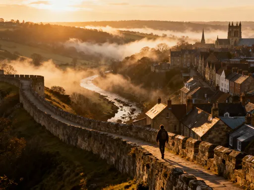
Up on the Walls: A View of the City’s True Shape
To truly understand York’s terrain, one must rise above it. The York City Walls, among the most complete medieval fortifications in England, offer more than just history—they provide a panoramic perspective on the city’s varied topography. As you walk the stone path atop the walls, the landscape unfolds in layers. Rooftops drop away into hollows, green spaces sink below street level, and the rivers snake through different elevations, revealing a city that is anything but flat.
From this elevated vantage, the subtle dips and rises become clear. You can see how the land falls toward the Foss, how the Shambles area lies in a distinct depression, and how the old town is ringed by natural and artificial mounds. The walls themselves follow the contours of higher ground, built where the earth provided the best defensive advantage. In places, the wall rises sharply; in others, it levels out, always responding to the land beneath it.
This aerial view transforms the way one understands York’s layout. What seems like a random jumble of streets from ground level begins to make sense when seen from above. The major roads avoid the lowest areas, while footpaths often follow the old watercourses. Parks and gardens occupy spaces that were once too wet for building. Even the placement of churches and towers often reflects elevation—higher ground for visibility and stability. Walking the walls is not just a tour of history; it’s a lesson in geography. It teaches travelers to see the city as a living landscape, shaped by both nature and necessity.
Through the Parks: Nature’s Clues to Ancient Ground
York’s green spaces are more than just pleasant places to rest—they are archives of the city’s buried terrain. In Museum Gardens and other public parks, the land reveals its original shape through gentle slopes, grassy mounds, and clusters of trees that mark old water sources. These parks were often created on land that was too marshy or uneven for development, preserving the natural contours that have been paved over elsewhere.
In the York Museum Gardens, for example, the ground undulates in ways that reflect its past as a monastic water garden. The old drainage channels are now ornamental streams, but their paths follow ancient flow lines. Raised walkways cross over low-lying areas that still collect moisture, a reminder of the site’s watery history. Even the placement of benches and flower beds often avoids the wettest zones, just as medieval builders once did. The trees—many of them centuries old—thrive in these pockets of deeper soil and retained moisture, their roots tracing the forgotten valleys.
For the attentive visitor, a walk through these parks becomes an act of discovery. A slight incline leads to a viewpoint over a sunken lawn; a paved path curves around a natural mound that may once have been a defensive earthwork. These features weren’t designed for aesthetics alone—they respond to the land as it was found. By preserving these spaces, York has kept alive a record of its pre-urban landscape. They invite slow exploration, quiet observation, and a deeper connection to the earth beneath the city.
Why This Hidden Terrain Matters Today
Understanding York’s hidden terrain does more than enrich a tourist’s experience—it fosters a deeper respect for how cities evolve in dialogue with nature. In an age of rapid development and climate challenges, York’s layered landscape offers valuable lessons. The city’s flood management strategies, for instance, still rely on knowledge of old watercourses and natural drainage patterns. Modern planners consult historical maps and geological surveys to anticipate where water will flow, just as medieval builders once did.
For travelers, recognizing these subtle features transforms a simple sightseeing trip into a more meaningful journey. It encourages mindfulness—looking down as much as up, noticing the slope of a street, the coolness of a shaded alley, the way trees cluster in certain spots. It shifts the focus from consumption to connection, from checking off landmarks to feeling the story of a place through its land. This kind of travel is slower, quieter, and ultimately more rewarding.
Moreover, appreciating York’s terrain supports preservation efforts. When people understand that a dip in the ground is not just a quirk but a remnant of centuries of adaptation, they are more likely to value it. They begin to see the city not as a static museum, but as a living system shaped by time, water, and human ingenuity. This awareness fosters stewardship, encouraging both locals and visitors to treat the city with care.
In a world where many destinations feel homogenized, York stands out for its depth—not just in history, but in geography. Its secret terrain reminds us that every city has layers waiting to be discovered. All it takes is curiosity, a willingness to look closely, and the simple act of walking with intention. The next time you visit, don’t just follow the guidebooks. Step off the main paths. Feel the ground beneath your feet. Let the land tell you its story. Because in York, the true wonder isn’t just what you see—it’s what you feel beneath your soles, in the quiet rise and fall of a city built on secrets.